Keeping the focus on the important Ag Enclave activities in St. Johns County, let’s catch up with what has happened in September.
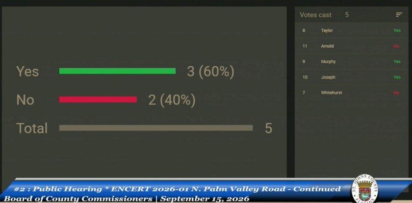
On September 15, the BOCC formally denied certification of the 4,462-acre N. Palm Valley Agricultural enclave by a 3-2 vote, with Whitehurst and Arnold casting the no votes. Just a few moments later they approved the 310-acre AFI Enclave, also by a 3-2 vote, with Taylor and Joseph casting the no votes.
What was important in that meeting was that with the denial of the N. Palm Valley Enclave, the county has the test case for the courts to decide if a local government can deny an application that county staff has determined meets the criteria for the Agricultural Enclave certification.
What was evident in discussion during the meeting was the chosen strategy – litigate in St. Johns County rather than Leon County. County Attorney Rich Komando relayed outside counsel’s recommendation that the best path was to deny the application, creating the opportunity for the applicant to challenge that denial.
This creates an interesting scenario. The Commissioners deliberately chose to deny the application in order to create the court challenge. Commissioner Murphy had stated previously there was “no legal reason to deny” the application. Now, he has reversed course and the implication from the dais was that the denial was done specifically to enable the county to challenge SB 686 in the courts.
There were a few public comments that challenging the law in court would allow insurance to cover the cost of the litigation. It will be interesting to see if the county’s insurance does cover litigation in a case that was intentionally created by the Commissioners to challenge this law. It is on record, in multiple meetings, that is the intent of the denial.
There were a few points in the meeting that you may want to hear for yourself how the discussion went. The first was in Public Comment when Commissioner Whitehurst encouraged anyone there to speak on the N. Palm Valley Enclave agenda item to speak up during General Public Comment. He was seeking clarification that the public comment portion for that agenda item was closed and the Commission was just continuing deliberations on Tuesday.
The stated criterion for denial presents an interesting question for the courts. And it could indeed set a precedent for Agricultural Enclaves across the state. The statute requires portions of an agricultural enclave perimeter to be surrounded by land designated and developed for industrial, commercial or residential purposes. The question being raised is, what qualifies as “existing industrial, commercial or residential development.”
The applicant’s argument is that surrounding properties in Nocatee and Roscoe Boulevard have been platted and therefore meet the statutory definition of development. The applicant’s attorney pointed out seawalls, drainage improvements, constructed homes and other physical evidence of development. County staff had independently reviewed the perimeter and concluded the application met the statutory threshold.
An attorney hired by anonymous residents, Brad Russell, argued that the law distinguishes the act of developing land from the resulting condition of “existing” residential, commercial or industrial development. His interpretation is that dividing property into parcels does not automatically turn every vacant lot, common tract or conservation area into existing residential development.
This could be pivotal for enclave certification across the state.
How did Mr. Russell become involved in the dispute?
Commissioner Joseph had reached out to Mr. Russell when the Ag Enclaves first came to her attention in July. He was known to Commissioner Joseph and the other Commissioners as he had represented Commissioner Joseph in her federal lawsuit against the county in 2024.
At the September 15 hearing, Mr. Russell stated he had been retained by a group of St. Johns County residents who wished to remain anonymous. In her comments, Commissioner Joseph praised his arguments against the certification and asked him back to the podium, highlighted his credentials and then asked if he had previously been successful litigating against a county.
This does not invalidate Mr. Russell’s arguments. It does raise a question about the disclosure of outside information and the impact on Commissioner votes.
During public comment, attorney Ellen Avery-Smith objected to the county holding what she characterized as a third public hearing on the application. She argued that SB 686 contemplates one staff report followed by one public hearing, that the hearing had been closed on September 1, and that the county should not continue accepting new evidence after that hearing concluded.
Here is a link to the hearing on September 15. I think it’s important to hear what was actually said as the Commissioners debated their votes: N. Palm Valley Public Hearing #3
Chair Murphy’s changing Votes
Commissioner Murphy had said repeatedly from the dais that he opposed the new law but saw no legal reason to deny N. Palm Valley. In the September 15 meeting he again talked about his opposition to the law and its impact on Home Rule in the county. He talked about carrying petitions to Tallahassee to seek repeal of the law. And then voted to deny. It was not clear from the dais what his reasons for denial were.
Since that meeting, Chair Murphy has appeared in news media carrying the banner for fighting back against SB 686.
What’s important to remember is that when this gets to court, the judge will not be deciding whether commissioners or residents dislike the law and want it repealed. The judge will examine the law, the evidence and the findings supporting the denial.
Staff and their Review
Growth Management staff have become the scapegoat in public debate. The criticism is confusing an unpopular statute with the staff members required to administer it.
Staff did not write or enact the statute. They are tasked with reviewing the applications against the Legislature’s criteria. There has been evidence that staff has challenged and disputed some of the criteria. This resulted in some applications being withdrawn and it appears the applicants were addressing the weaknesses before resubmitting.
There is clear evidence of staff’s independent review. There is no evidence that the staff blindly accepted developers’ claims as is speculated in social media.
Commissioners may reject a staff recommendation when the record supports a different finding. They should specify the contrary evidence behind their differing conclusion. There were questions asked and points debated, but no clear explanation from the dais connecting the differing evidence to the statutory criteria.
It’s unfair to treat the professional staff, our neighbors and fellow residents, as suspect because their analysis produces an answer we don’t like. That weakens our local governance that we are trying to protect from Tallahassee.
Insurance does not make litigation free
Several speakers and Commissioner Joseph suggested the county’s insurance would bear the cost of litigation, rather than taxpayers directly. We pay for that insurance. It is part of the county budget funded by taxpayers. Depending on the policy, the county may also be responsible for deductibles, staff time, outside experts, consultants, uncovered claims or costs exceeding policy limits. Just like our auto and homeowners insurance policies, claims history can affect future premiums and coverage terms. There may even be limits to when and how they will cover litigation.
Before treating litigation as costless, we need to understand the applicable deductibles, whether the carrier accepts the defense, and what categories of expense remain the county’s responsibility.
The final order will matter
It was clear that the applicant’s attorney was prepared for this denial. She offered a clear rebuttal for Mr. Russell’s interpretation, defense of the evidence in the record and preserved an objection to the procedure after Commissioner Joseph made her motion before all Commissioners had finished identifying whether new information affected the decision. Why is that important? The applicant may argue that the timing of the motion indicates Commissioner Joseph had decided how she intended to vote before all the evidence and commissioners’ discussion were complete. This is evidence of an experienced land-use attorney anticipating litigation that the commissioners had openly discussed.
The County has now assumed the burden of defending a denial that its professional staff did not recommend. The final written order will have to identify the findings of fact and legal conclusions supporting the denial. That means the county must clearly explain which evidence the Board accepted, which statutory requirement it concluded was not met, and how it reached a conclusion different from its professional staff.
Another surprise twist
During Commissioner reports on the 15th, another surprising twist happened. Commissioner Whitehurst recommended that two previously approved Enclaves, Heritage East and Heritage West, be brought back before the Board for consideration. As one of the Commissioners who had voted to approve these previously, he had the right to call for this reconsideration. The vote to bring those back was 4-1, with Commissioner Murphy voting no.
There is a Special Meeting scheduled for September 28 to rehear those applications.
More Legal Happenings
It was no surprise that the PARC Group, represented by Attorney Ellen Avery-Smith, has indicated they are filing an appeal of the N. Palm Valley denial. That would most likely be filed in the St. Johns County Circuit Court. The challenge must be filed within 30 days after the county issues its final written decision.
In the case of the Heritage East and West applications being brought back to the Board on Monday, 9/28, the owner, Chris Shee, filed an emergency petition on September 23, to block the special hearing on Monday, September 28.
The argument from the developer is that there was no duly noticed meeting and agenda and also SB686 does not give the county the leeway to reconsider an application they already approved.
As of September 27, we have not seen the court’s response to that petition.
If you are finding value in these updates, please subscribe to my blog so you get notifications when I publish an update. Feel free to share with others who may find value in the content.
North Palm Valley Agricultural Enclave: No Approval, No Denial—and the Clock Is Still Running
With 13 items on Tuesday’s agenda, it was going to be a long meeting regardless. But the continued hearing on the North Palm Valley Road Agricultural Enclave certification became the dominant—and most procedurally confusing—discussion of the day.
I’ll keep this post focused on the Agricultural Enclave. Watch for my next post addressing the proposed conservation property-tax levy scheduled for the November 3 ballot.
The North Palm Valley application remained Agenda Item 3 but was moved forward to be heard second, at Commissioner Krista Joseph’s request, because so many residents had come to speak, including some who had taken time away from work.
Even before the item was heard, however, the public comment process became confusing. Commission Chair Clay Murphy allowed residents to address the Agricultural Enclave during general public comment, even though the application remained on the regular agenda for a continued public hearing. The Board’s published rules describe general public comment as the opportunity to address matters not scheduled on the regular agenda.
Some residents spoke then. Others believed they would be able to speak after the applicant’s presentation when the formal hearing resumed. That created understandable confusion over whether public comment on the application had already occurred and whether residents who waited for the agenda item would still be heard.
Several recurring themes emerged during public comment, many of them echoing legal and factual arguments that had circulated on social media before the meeting.
Themes in Public Comment on Ag Enclaves:
Most speakers addressing Senate Bill 686 and the North Palm Valley Road certification raised similar concerns, including:
Whether the applicant could use a metes-and-bounds description to carve approximately 4,462 acres out of larger tax parcels containing more acreage;
Whether the statutory January 1, 2025 eligibility date had been satisfied;
Whether at least 50 percent of the property’s perimeter was surrounded by qualifying development;
Whether vacant but platted lots should count as “developed” property;
Whether the land had been continuously used for bona fide agricultural or silvicultural purposes;
Potential impacts on groundwater, water pressure and future water supply;
Environmental impacts, including wetlands, wildlife habitat, drainage and flooding;
Transportation, school and public-service demands;
The potential financial burden on existing residents for infrastructure required by future development;
The loss of local government authority under the new state law; and
Whether the County should deny the application and defend that decision in court rather than initiate a separate challenge to the statute.
One speaker supported a more pragmatic approach to eventual development and cautioned against treating “no development” as the only acceptable outcome.
Item 3: North Palm Valley Road Agricultural Enclave certification
The approximately 4,462-acre application had been continued from August 19 so staff could review the northern boundary for compliance with Sections 163.3162 and 163.3164, Florida Statutes. County staff and the applicant characterized the northern-boundary question as the limited purpose of the continued hearing. Several residents and commissioners nevertheless raised broader questions about whether the application satisfied the statute.
The applicant’s land use attorney made that point clear and reminded Commissioners that if public comment after the applicant’s presentation on the boundary analysis strayed into other topics, that would give the applicant leeway to bring rebuttal to those comments.
Growth Management Director Mike Roberson reported that the County surveyor had reexamined the legal description. Staff found that the metes-and-bounds description closed properly and constituted an accurate legal description of the property.
The applicant’s attorney, Ellen Avery-Smith, presented that:
Florida law defines a parcel as land capable of being described with sufficient definiteness to establish its location and boundaries;
The owner may designate the portion of the land to be used or developed as a unit;
Fifth District Court of Appeal precedent permits the owner to define a parcel through a metes-and-bounds legal description;
The application therefore could include approximately 4,462 acres without including the entirety of every underlying property identification number; and
The situation differed from the Orange County example Ag Enclave application, cited by some residents in Public Comment. In the example application, the applicant relied on tax parcel numbers and a map but did not provide a separate metes-and-bounds description.
Arguments Presented During the Continued Hearing
During the continued hearing, residents challenging the application focused more specifically on the boundary analysis and the evidence supporting the statutory criteria. They argued that:
The boundaries may have been drawn specifically to remain below the statutory 4,480-acre ceiling;
Portions of existing tax parcels could not necessarily be treated as independent qualifying parcels as of January 1, 2025;
The applicant had not adequately demonstrated that at least 50 percent of the perimeter was surrounded by qualifying urban development;
Vacant platted lots, seawalls and subdivision plats should not automatically be treated as qualifying development;
The historical agricultural or silvicultural use of the property had not been adequately documented;
The Board should require parcel-by-parcel evidence supporting the perimeter calculation; and
The broader environmental, water and infrastructure consequences justified denial or, at minimum, additional independent review.
One specific point of dispute was whether intentionally vacant land within approved developments to the south should be considered “developed.” The applicant responded that platting is itself included within Florida’s statutory definition of development and provided subdivision plats, property records and other materials intended to substantiate the perimeter calculation.
Commissioners’ discussion
Commissioner Whitehurst said County staff had repeatedly concluded that the application met the statute, even after the Board requested additional scrutiny. He distinguished the certification proceeding from an ordinary rezoning, where the Board has broader discretion, and said the Board’s responsibility was to apply the limited criteria established by state law.
Chairman Murphy also said he believed the applicant had demonstrated compliance and that the law itself—not an individual application that appeared to meet its requirements—should be challenged. However, when the approval motion was made, Murphy joined Commissioners Joseph and Taylor in voting against it. Murphy had also voted against denial. With the chairman opposing both possible dispositions, neither motion received the three votes needed for Board action.
Commissioners Taylor and Joseph maintained that both the statute and the supporting evidence remained subject to interpretation. They favored denying the application and allowing a court to determine whether the applicant had established the required acreage, boundaries and surrounding development.
Motions and outcome
The Board took three consequential votes, which caused quite a bit of confusion.
Motion to deny the certification: Failed 3–2. (Commissioners Whitehurst, Arnold and Murphy voting no)
Motion to retain outside counsel and pursue legal action against Senate Bill 686, potentially including injunctive relief: Passed 3–2. (Commissioners Whitehurst and Arnold voting no.)
County counsel cautioned that outside attorneys viewed an affirmative County challenge as an uphill fight, particularly regarding standing, and had previously suggested that the County would be in a stronger position defending a local denial.
Motion to approve the Agricultural Enclave certification: Failed 3–2. (Commissioners Joseph, Taylor and Murphy voting no.)
The Board therefore ended the September 1 meeting in an unusual position. A majority opposed denying the application, but a different majority also opposed approving it.
The property was not certified by the Board on September 1, but the application was not denied. Under the statute, if the County does not formally approve or deny the request within 90 days of receiving it, the property must be certified as an Agricultural Enclave.
At the September 3 budget hearing, Commissioner Joseph requested that the North Palm Valley application be placed on the Board’s September 15 agenda. If placed on that agenda, the application will return to the Commission before the statutory deadline, giving the Board another opportunity to take formal action.
The September 1 votes did not resolve the application, but they revealed the divisions that will follow it into the next hearing. Commissioners Joseph and Taylor supported denial. Commissioners Arnold and Whitehurst supported approval. Chairman Murphy voted against both motions while supporting a separate legal challenge to Senate Bill 686.
The central question for September 15 will be whether one of those positions changes—or whether the Board again fails to reach the three votes required for either approval or denial.
If you are finding value in these updates, please subscribe to my blog so you get notifications when I publish an update. Feel free to share with others who may find value in the content.
What really happened at the Ag Enclave Certification Meeting on Wednesday, August 19.
Spoiler: Thousands of homes were NOT approved
At its August 19 meeting, the St. Johns County Board of County Commissioners considered three applications for agricultural-enclave certification: Heritage Development East, Heritage Development West and N. Palm Valley Road.
The nearly four-hour hearing revealed substantial confusion about what certification does—and does not—approve.
What is most important was the clarification from Deputy County Attorney Kealey West about the Board’s task on Wednesday. It was a very narrow, quasi-judicial lane. Did each application meet the criteria established in SB 686 for an agricultural enclave? It was not a policy vote on whether the Commissioners liked the potential development. The commissioners had to base their decisions on the statutory criteria and the competent, substantial evidence in the record—including the application materials, staff’s review and evidence presented during the hearing.
Statutory maximum discussed as 13 units per acre; no development plan presented
Certified 3–2
Heritage Development West
Approximately 551 acres
Statutory maximum discussed as 13 units per acre; no development plan presented
Certified 3–2
N. Palm Valley Road
Approximately 4,462 acres
Applicant requested 1 unit per acre
Continued to September 1
The two Heritage certifications passed 3-2, with Commissioners Joseph and Taylor voting no.
A motion to deny N. Palm Valley failed 2–3 with Commissioners Whitehurst, Murphy, and Arnold voting against denial.
Before a motion to approve was made, Chairman Murphy requested a continuance to allow staff to reexamine the boundary calculations, particularly the northern boundary. The continuance passed, 4–1 with Arnold being the no vote.
The applicant argued that the two parcels met every statutory criterion:
Approximately 615 acres, within unincorporated St. Johns County.
Owned or controlled by one entity.
Undeveloped as of January 1, 2025.
Used for timber production and classified as agricultural for at least ten years.
Surrounded by qualifying future land-use designations along more than the required percentage of the perimeter.
Within the County’s development area boundary.
Under the statutory acreage cap.
Located in a county with fewer than 1.75 million residents.
The applicant agreed to enter into a binding agreement to provide or pay for required public services.
The applicant said the certification could permit densities up to 13 units per acre based on surrounding land uses. However, counsel acknowledged that 13 single-family homes per acre was probably not a realistic product and said the actual density and development layout would not be known until a development plan was submitted.
Note the important statement there – until a development plan was submitted. A development plan must still be submitted even though the property was certified as an agricultural enclave.
Staff concluded that the application satisfied the agricultural-enclave definition.
Questions from commissioners
Commissioner Whitehurst focused on the distinction between the statutory maximum and actual development. He asked whether a single-family product could realistically achieve 13 units per acre. The applicant said he was unaware of such a product and that setbacks, wetlands and other land-development regulations would affect the final yield.
Commissioner Joseph questioned whether the property had previously been denied, what activity had occurred on the timber property during the previous five years, and whether people, trucks and logging operations were regularly present. The applicant could identify it as a timber operation but could not provide the date of the last harvest or replanting from the podium.
The statute requires the property to have been in continuous bona fide agricultural use for at least five years before the application. The applicant submitted historical aerial imagery showing continued timber use, and County staff independently verified that the property had received an agricultural classification and assessment from 2015 through 2025. Staff concluded that the application demonstrated compliance with the agricultural-use requirement.
Public comment
I normally do not include public comment in my reports. I’m sharing here the highlights because it is important to understand where there is confusion about the certification hearing and what comes next in the process.
Public comment focused primarily on infrastructure, maximum potential density, wetlands and the argument that the County Comprehensive Plan remained controlling. A second line of argument questioned whether agricultural classification and tax-parcel boundaries were sufficient evidence under the statute.
Applicant rebuttal and legal clarification
County Attorney West directly rejected the central Comprehensive Plan argument. She explained that the new law begins with “notwithstanding any other law” and creates a limited statutory preemption. For certification, the Board had to apply the agricultural-enclave criteria rather than the County Comprehensive Plan.
Wetlands, environmental permitting, setbacks and other development regulations would still apply.
A future development plan would still be reviewed by County staff.
Public-services agreements were specifically allowed by the statute.
No public speaker had produced competent evidence contradicting the application’s acreage, ownership, perimeter calculations or agricultural classification.
Board discussion and vote
Commissioner Taylor moved to deny, citing unanswered questions about bona fide agricultural use. Commissioner Joseph seconded.
Commissioner Whitehurst asked what competent evidence had been presented showing that the property was not a bona fide timber operation. He noted that timber production does not require daily activity and questioned whether the proposed denial could be legally defended.
Commissioners Taylor and Joseph voted to deny despite staff findings of compliance and did not identify contrary evidence sufficient to persuade the majority.
The denial failed 2–3. A subsequent motion to certify passed 3–2.
The second Heritage presentation was largely parallel to the first because it involved the same owner and statutory framework.
The applicant represented that:
The application covered three parcels totaling approximately 551 acres.
The parcels were undeveloped and under single ownership or control.
The land had been used for timber production and classified as agricultural.
More than 75% of the perimeter qualified under the applicable surrounding-development test.
The applicant offered to enter into agreements for required public services.
The property met the acreage and county-population limits.
County staff found that the application met the statutory definition.
As with Heritage East, the presentation discussed a maximum potential density of 13 units per acre calculated from surrounding land uses under the statute, but no development plan or actual unit count was presented.
Public comment
Public comment expanded during the West hearing.
Similar arguments were repeated during the Heritage West hearing, despite County counsel’s earlier explanation that SB 686 creates a limited preemption for the certification decision. Other comments addressed schools, agricultural documentation, parcel boundaries, traffic, wetlands and wildlife.
The agricultural-use evidence was substantially the same as for Heritage East: historical aerial imagery, a reported timber operation dating to 1956, and agricultural classification and assessment from 2015 through 2025. County staff independently reviewed the records and found that the application satisfied the statutory requirement.
Applicant rebuttal and staff response
The applicant emphasized that the property appraiser classifies agricultural and nonagricultural land annually under Section 193.461. Therefore, the classification was not a one-time designation from many years earlier.
Counsel also explained that:
The statutory definition of “parcel of land” does not prohibit using a property-appraiser parcel.
Agricultural classification was supported by the property appraiser’s annual review.
The offer to provide or pay for required services was the alternative expressly authorized by the statute.
County staff confirmed that it had consulted with Property Appraiser Eddie Creamer and his staff, reviewed their agricultural-classification methodology, and was comfortable with the determinations.
Board discussion and vote
Chairman Murphy gave one of the clearest summaries of the Board’s dilemma. He said St. Johns County was suffering from growth fatigue and that he disliked the state preemption, but his personal view of growth was not the legal standard. He said he could not identify a legally supportable reason to deny an application that staff concluded met the law.
Commissioners Taylor and Joseph again voted to deny despite staff findings of compliance and did not identify contrary evidence sufficient to persuade the majority.
Heritage West was certified 3–2.
3. N. Palm Valley Road
This hearing was substantially longer and produced more focused statutory challenges than the Heritage hearings.
The applicant emphasized that the application contained more than 500 pages of supporting material, including:
A signed and sealed legal description and survey.
Deeds and ownership records.
Property-appraiser records.
A timber-management plan.
Timber-sales information.
Sworn affidavits.
Perimeter and surrounding-development calculations.
Letters concerning utilities, schools and other public services.
The applicant repeatedly corrected the claim that it was seeking six units per acre:
The request was one single-family residential unit per acre—approximately 4,462 units—not 26,772 units.
County staff had calculated that the statute could support a maximum of six units per acre based on surrounding land uses, but that was not what the applicant requested. Later in the hearing, County staff said the one-unit-per-acre commitment would be incorporated into a future development agreement, and applicant’s counsel stated on the record that there would be no more than 4,462 units.
The applicant argued that the property met the applicable 75%/50% perimeter test:
Approximately 84% of its perimeter was adjacent to qualifying residential, commercial or industrial designations.
Approximately 50.88% qualified as existing development.
The calculations were based on a signed and sealed survey.
Land across the Intracoastal Waterway, in Nocatee and in Duval County was used in the analysis.
The statute expressly requires looking across rights-of-way, bodies of water and canals.
Nothing in the statute prohibits considering land in an adjacent jurisdiction.
The applicant also explained that certification did not eliminate:
Wetlands and environmental permitting.
Transportation analysis.
School concurrency.
Proportionate-share requirements.
Utility permitting.
Construction-plan review.
County land-development regulations.
Commissioner questions before public comment
Commissioner Joseph questioned:
The Davis family’s ownership of adjoining land in Duval County.
Why the owner did not proceed through the ordinary public development process.
Whether the one-unit-per-acre commitment could later be increased.
Where traffic would go.
Whether an independent forester should inspect the property.
When timber had last been planted or harvested.
The applicant responded that the property had a timber-management plan, timber-sales information, a full-time property manager and agricultural records. Counsel declined to agree that an additional inspection was necessary.
Commissioner Taylor asked how the one-unit-per-acre representation could be guaranteed. Staff responded that the statute establishes potential density from surrounding land, but the applicant’s one-unit commitment would be written into the future development agreement.
Chairman Murphy asked whether the owner could later use this certification to qualify adjoining land to the north. Counsel cited language prohibiting an applicant from using the perimeter of one certified enclave to qualify another.
Public comment: the stronger statutory challenges
Some of the N. Palm Valley comments were much more closely connected to the actual certification criteria than comments made during the Heritage hearings.
Whether the 50% test should measure the percentage of the surrounding parcels that is developed rather than the percentage of the enclave perimeter touching development.
Whether the qualifying acreage existed as a legally defined configuration as of January 1, 2025.
Whether the application relied on a boundary drawn in 2026 rather than the parcels existing in 2025.
Whether the approximately 50.88% result depended on an impermissible calculation.
Whether the one-unit-per-acre representation was legally binding.
The meaning of “the local government” in the statute.
Whether the 50% test was being applied to perimeter length rather than the area or condition of the surrounding parcels.
Whether the Board should continue the hearing to obtain a written legal analysis.
Whether land in another county could be considered at all. This was an interesting statutory question, although the applicant argued that the law requires examination of surrounding lands and contains no same-county restriction.
Those were the portions of public comment most directly relevant to the Board’s certification decision.
Public comment: development-impact arguments
A large portion of the remaining public comment concerned:
Traffic on Palm Valley Road, Roscoe Boulevard, A1A and Nocatee Parkway.
School construction and taxpayer debt.
Water pressure and potable-water supply.
Wetlands, wildlife, tree removal and climate impacts.
The lack of a transportation plan.
Residents’ loss of public input over the eventual development plan.
General opposition to rapid growth.
Requests that the Board “fight” the statute in court.
These are legitimate development concerns. However, they generally did not rebut the applicant’s evidence on the statutory certification criteria. The development plan for the property is not part of the certification process.
Several speakers explicitly acknowledged that they did not understand the legal process or were not attempting to make a statutory argument. Their comments were largely appeals to deny or delay development based on its anticipated impacts.
Applicant rebuttal
The applicant responded point by point:
The application boundary was supported by a signed and sealed legal description and survey.
The alternative map displayed by a public speaker was not the map in the application.
The statutory definition permits an owner or developer to designate a describable parcel of land.
The long parcel along the Intracoastal was included in the timber-management plan and sworn agricultural-use testimony.
The 50.88% calculation came from surveyed boundary dimensions.
“Development” under Chapter 380 can include subdivision of land, shoreline alteration and other improvements; a parcel need not contain a completed house to constitute existing development.
The statute does not prohibit considering adjoining land in Duval County.
JEA had provided a letter stating that it could serve the property.
The project would still undergo concurrency and development-plan review.
The applicant committed on the record to no more than 4,462 units.
The applicant submitted a Property Appraiser letter, property records, aerial imagery, a timber-management plan, timber-sales information and sworn testimony concerning the property’s agricultural use. Staff reviewed the documentation and independently concluded that the property had been in continuous bona fide agricultural use for the required five-year period.
Board discussion and continuance
Commissioner Taylor moved to deny based on insufficient proof of agricultural use and inadequate infrastructure under the Community Planning Act. Commissioner Joseph seconded. The motion failed 2–3 with Commissioners Whitehurst, Murphy and Arnold voting against denial.
Before an approval motion was made, Chairman Murphy asked for a continuance. He said public comment had raised questions about the boundary calculations that he wanted staff to examine more fully.
The Board voted 4-1 to continue the hearing until September 1 and directed staff to recheck the boundary, particularly in the northern portion, using GIS. Commissioner Joseph also requested an independent forestry review and renewed Community Planning Act analysis, but the Board did not reach consensus on those requests.
Commissioner Whitehurst cautioned against imposing a more demanding evidentiary standard on N. Palm Valley than the Board had applied to the two Heritage applications.
What the hearing clarified—and what it did not approve
The most persistent confusion throughout the hearing was the belief that certification approved thousands of homes for immediate development.
It did not.
No development plan was before the Board for any of the three applications. Certification determines whether property meets the definition of an agricultural enclave established by state law. It does not eliminate the later requirements for environmental permitting, concurrency, transportation analysis, utility review, construction plans or compliance with applicable land-development regulations.
Maximum density is not a development plan
The Heritage properties were discussed using a statutory maximum of 13 units per acre. Those maximums were repeatedly converted into claims that approximately 8,000 homes had been approved on Heritage East and 7,000 on Heritage West.
No such development plans were presented or approved.
The applicant acknowledged that it was not aware of a single-family housing product that could realistically achieve 13 units per acre. Wetlands, setbacks, infrastructure requirements and other development regulations will affect the ultimate number and location of homes.
The same confusion surrounded N. Palm Valley. The statute could support a maximum of six units per acre based on surrounding land uses, but the applicant requested one unit per acre from the beginning—approximately 4,462 units, not 26,772. During the hearing, the applicant committed on the record to that limit, and County staff stated that it would be incorporated into the development agreement.
Infrastructure concerns did not automatically defeat certification
Many comments focused on roads, schools, utilities and other infrastructure. Those concerns will matter as development plans are prepared and reviewed, but existing infrastructure deficiencies were not an automatic basis for denying certification.
SB 686 expressly allows an applicant either to demonstrate that required public services exist or to agree to provide, fund, construct or dedicate land for those services.
The argument that the County Comprehensive Plan nevertheless allowed commissioners to deny certification was also addressed directly by County Attorney Kealey West. She explained that SB 686 creates a limited preemption for the certification process. The Board was required to apply the agricultural-enclave criteria established by state law—not the County’s ordinary discretionary standards for a Comprehensive Plan amendment.
Questions are not evidence of noncompliance
Commissioners Taylor and Joseph questioned whether the properties had been in bona fide agricultural use and supported motions to deny. However, County staff had reviewed the applications, consulted with the Property Appraiser’s Office and found that the agricultural-use requirements were satisfied.
Commissioner Whitehurst repeatedly asked what competent, substantial evidence had been introduced to contradict those findings. Questions about when timber was last harvested, whether workers were present every day or whether additional inspections might provide greater comfort did not, by themselves, establish that the statutory requirement had not been met.
The majority ultimately concluded that the Heritage applicants had demonstrated compliance and that the record did not support denial.
Why N. Palm Valley was continued
N. Palm Valley produced a different result because some questions were tied more directly to the statutory certification test.
Those questions concerned the application boundary and the calculations used to determine whether the property met the required surrounding-development percentages. Chairman Murphy requested additional time for staff to recheck the boundary, particularly along the northern portion of the property.
The hearing was continued to September 1. The application was neither approved nor denied.
The real divide at the hearing
The commissioners were not deciding whether additional growth was good for St. Johns County. They were deciding whether each property met a definition created by the Florida Legislature.
That distinction was uncomfortable but controlling.
Commissioners could dislike the law, oppose state preemption and share residents’ concerns about infrastructure. What they could not responsibly do in a quasi-judicial hearing was deny an application solely because they opposed the development that might eventually follow.
Heritage East and Heritage West were certified because the majority concluded that the applications met the statutory requirements. N. Palm Valley was continued because the majority wanted one certification issue—the boundary calculation—examined more closely.
Thousands of homes were not approved on August 19. Two properties were certified as agricultural enclaves, and one certification hearing remains open.
If you are finding value in these updates, please subscribe to my blog so you get notifications when I publish an update. Feel free to share with others who may find value in the content.
Heritage East is a proposed agricultural enclave of approximately 615.41 acres near State Road 207 and Interstate 95 in St. Johns County. County staff has completed its certification review, determined that the application passes the statutory certification test, and forwarded the matter for review by the Board of County Commissioners at the August 19, 2026 public hearing.
Based on the application materials currently available, Heritage East appears to satisfy the threshold requirements for certification, including acreage, county population, common ownership, agricultural-use history, and the qualifying Future Land Use Map perimeter test. Staff’s conclusion that the application passes the certification test has also been confirmed in press reporting.
Several matters should nevertheless be clarified or documented in the certification record:
Public services: The application asserts that water, wastewater, transportation, schools, and recreation facilities are available or scheduled, but provides little supporting capacity documentation. Its statement that the applicant will negotiate “to the extent necessary” is less definite than an express offer to enter the binding proportionate-share agreement described in the statute.
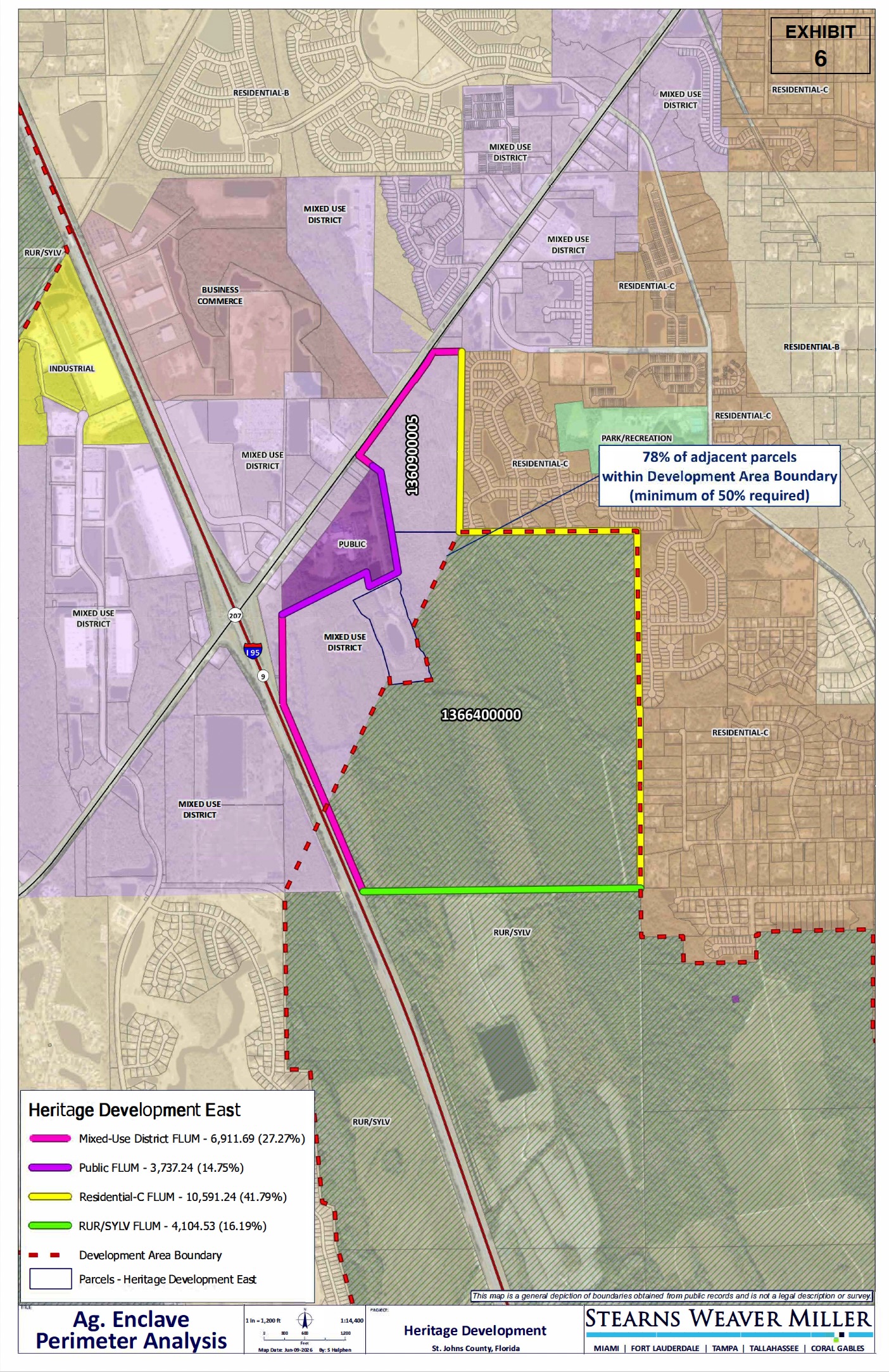
Urban-service perimeter: The applicant calculates that 78% of the perimeter meets the urban-service requirement by using the County Development Area Boundary. The County should expressly confirm that this boundary qualifies as an urban service district, area, or line and independently verify the calculation.
Density and proposed uses: The requested density of 13 units per acre appears supportable if the identified adjacent Mixed Use property legally permits the same density. The application also references commercial and industrial uses, but the authority for those uses appears tied to a different statutory pathway than the under-700-acre route claimed for certification.
Conservation easements and environmental review: Recorded conservation-easement areas should be mapped and reconciled with the certification boundary and perimeter calculations. The County site previously showed two Environmental Review comments and one Recreation Review comment; staff’s completed review indicates those comments did not prevent a favorable certification determination.
Overall assessment: Heritage East passes the staff-level certification review and is ready for consideration by the commissioners. The remaining points identified in this assessment are matters to understand in the final record or in later development review, not a basis for predicting that certification will fail.
This is an independent review of the application materials and County information publicly available as of August 13, 2026. It is not a County staff report or a legal determination. Where this assessment says a requirement has not been demonstrated, that means I did not find sufficient support in the publicly available materials reviewed; it does not necessarily mean the evidence does not exist or cannot be provided as the County’s review continues. I welcome corrections supported by publicly available documentation.
About this review: I am not an attorney, and this is not a legal opinion. I am a former Chief Audit Executive with decades of experience evaluating evidence against federal, state, local and international requirements. This assessment applies that evidentiary lens to the publicly available application materials; it is not a recommendation that the County approve or deny the application.
Disclaimer: I am not an attorney, and this is not legal advice. This assessment is my independent review of the application materials and County information publicly available as of August 10, 2026. The Heritage East application remains under active County review, and additional information may be submitted before the scheduled public hearing.
Location map from application
This executive summary is based on a more detailed review of the publicly available application materials against the requirements of SB 686. Because the County’s review remains underway and the public record may continue to change, I am not publishing the full working analysis at this stage. I will update this assessment as additional County findings and application materials become available. The supporting analysis is available upon request for those seeking to understand the methodology or documentation supporting a particular observation.
Detailed SB 686 Checklist Assessment
This assessment is based on the application materials reviewed and the County status reported as of August 12, 2026. It distinguishes between requirements that appear satisfied and matters that may still warrant clarification in the public record or later development review.
County review status as of August 12, 2026
Public hearing: Scheduled for August 19, 2026.
Applicant’s requested density: 13 units per acre.
Statutory maximum density: 13 units per acre.
County review comments: The County site previously showed two Environmental Review comments and one Recreation Review comment. Staff has nevertheless completed the certification review and concluded that the application passes the statutory test.
Application status: County staff has completed its review, determined that Heritage East passes the certification test, and placed it before the commissioners for the August 19 hearing. The August 12 site entry stating “Do not send comments out” appears to be an internal workflow instruction; without further explanation, it should not be treated as a substantive certification finding.
Project description: Certification of Two Parcels as an Agricultural Enclave Per Sections 163.3162(4) and 163.3164(4), Florida Statutes. This certification request is identified as ENCERT 2026-05 Agricultural Enclave Certification (Heritage Development East) and includes approximately 615 acres. The subject property is located East of Interstate 95 and south of State Road 207.
Note: I am using AI generate templates and maintain consistency across the reports I’ve prepared.
If you are finding value in these updates, please subscribe to my blog so you get notifications when I publish an update. Feel free to share with others who may find value in the content.
Three agricultural enclave certification applications scheduled for the August 19 St. Johns County Commission meeting have now been withdrawn by their applicants.
Star IV Investments, involving approximately 176 acres, was withdrawn on August 7, 2026.
Adler Creek, involving approximately 594 to 610 acres, was withdrawn on August 10, 2026.
Osceola Lakes, involving approximately 1,133 acres, was also withdrawn on August 10, 2026.
The withdrawal of three applications within four days is a significant change to the agricultural enclave matters expected to come before the County Commission on August 19.
AI generated view of Ag Lands
I previously published separate assessments of all three applications based on the application materials and County information publicly available at the time. Those assessments will remain available as records of the applications as submitted and the questions identified during the County review process.
Withdrawal means these applications will not proceed to the County Commission for certification on August 19. It is not the same as a denial. From what I can ascertain, County Staff had not completed their certification review, although some review questions were noted in the record. The Commission will not be voting on whether any of the three properties satisfied the statutory requirements for certification under Florida’s new agricultural enclave law.
The withdrawals also do not establish a formal County interpretation of the law or create a precedent for the applications that remain under review.
I have not yet seen a publicly documented explanation for the withdrawals. Unless the applicants provide additional information, it would be inappropriate to assume that all three were withdrawn for the same reason—or to speculate about whether they may be revised and resubmitted later.
What is clear is that the August 19 agenda has changed substantially. Three large and closely watched applications will no longer be considered, while the broader questions surrounding the new agricultural enclave law—and the remaining applications—are not yet resolved.
I will continue following the County’s review process and reporting material developments as they occur.
Assessments of the remaining 2 Ag Enclave certification requests scheduled for August 19 will be published this week. They are the Heritage Development East and West. Two more applications have been filed and are scheduled to be heard by the Commissioners in September.
If you are finding value in these updates, please subscribe to my blog so you get notifications when I publish an update. Feel free to share with others who may find value in the content.